Ohrid Lake - the Balaton of North Macedonia
The highest mountain in the Pelister National Park, you can never guess, is Pelister Mountain, 2601m.
The so-called "Rocky Trail" starts off through lush forest, steadily gaining elevation up a number of switchbacks.
Then you get to the rocky part. Climbing over and through large granite boulders, all rather rough and exposed, over the peaks of Stiv and Ilinden, you eventually reach the summit of Pelister.
In theory, you have great views all around as soon as you leave the forest. It should only be theory once more. We are not sure what it is thatˋs in the air, but it has been very hazy for days now, and the views have therefore been less than spectacular.
Nevertheless, the climbing over the boulders is good fun, if you are into that kind of stuff.


 |
| Not the prettiest decoration for a summit |


 |
| Looking back up to Pelister |

After a rather sweaty climb, we drove to Prespa Lake for a refreshing swim as well as to spend a quiet night at its shores.
 |
| Our watchdog for the night. No photos of the lake, as it was so hazy that you could only see blue shadows. |
The lake lies on the tri-point of North Macedonia, Albania and Greece and is the sister lake of the more well-known and touristy Ohrid lake.
The two are separated by the Galicica mountain range and National Park.
While Prespa Lake has been left rather natural, with very little infrastructure for tourists, Ohrid Lake reminded us a lot of Lake Balaton.
Although, whereas Balaton is very shallow, Ohrid Lake is almost 300 meters deep in places.
The whole area around the lake is a favorite holiday destination for North Macedonians and is taken as a substitute for the missing ocean.
There are tourist here, but as in all of NM, they are far outnumbered by "in-country-holiday-makers".
Plenty of larger and smaller cities and settlements are scattered along its shoreline, with Ohrid being the largest of them.
Here you can find all the creature comforts one might be looking for. Plenty of cafés and restaurants lining the waterline, lots of boats offering cruises on the lake, a nice pedestrianized walkway and cheap shopping opportunities.


 |
| A traditional paper makerˋs workshop |
 |
| Mr. Panevski working his Gutenberg press, one of only three in the world |

 |
| Plenty of churches and monasteries to go around in Ohrid |


From Samuelˋs Fortress, a structure from the turn of the 11th Century when Ohrid was the capital of the first Bulgarian empire, you get a brilliant 360 degree view of the entire area. On a clear day, that is...
 |
| The newer part of the city |
 |
| The old part |
 |
| You canˋt see me, but I am parked behind that football field with a nice view of the lake |


Struga, 20km down the road, is a bit more relaxed, but still has quite a buzz going.
The Black Drin originates here out of the lake with quite a current and flows through the city. The banks are lined on both sides with eateries and hip cafés, inviting you to sit right by the riverside and watch the kids jump into the water to drift with the flow of the water.
 |
| The path into town from our campground |
 |
| The birthplace of the Black Drin |


 |
| By the river or rather the rooftop terrace? |

 |
| Midnight skies |
Just to be able to say that we have been to all the National Parks in NM, not too hard to do with there being only three, we drove into the Galicica National Park for a short route up Magoro, from where you can see both lakes, Prespa and Ohrid.
Once again, it was quite hazy. But I am sure you expected nothing less.

 |
| The most useless billboard to every be installed - nothing on it and no-one to see it |

On the short drive to the border with Albania, we stopped briefly at the Monastery of St. Naum.
Founded in the 9th Century by the writer and "enlightener" Saint Naum himself, it is one of the most popular tourist destinations in the country.


 |
| The waterhead of the Ohrid lake |
The first town across the border is Pogradec, where we stopped to watch Albanias last group game in the European Cup against Spain.
There was a little motorcade before the game. Seems like they knew there wouldnˋt be reason for one after...
Pogradec is the biggest settlement on the 35km of Albanian shoreline of the Ohrid lake. The beachfront is lined with cafès and restaurants renting sunbeds and umbrellas.
Unlike other border towns, this one is actually really pleasant and well kept.

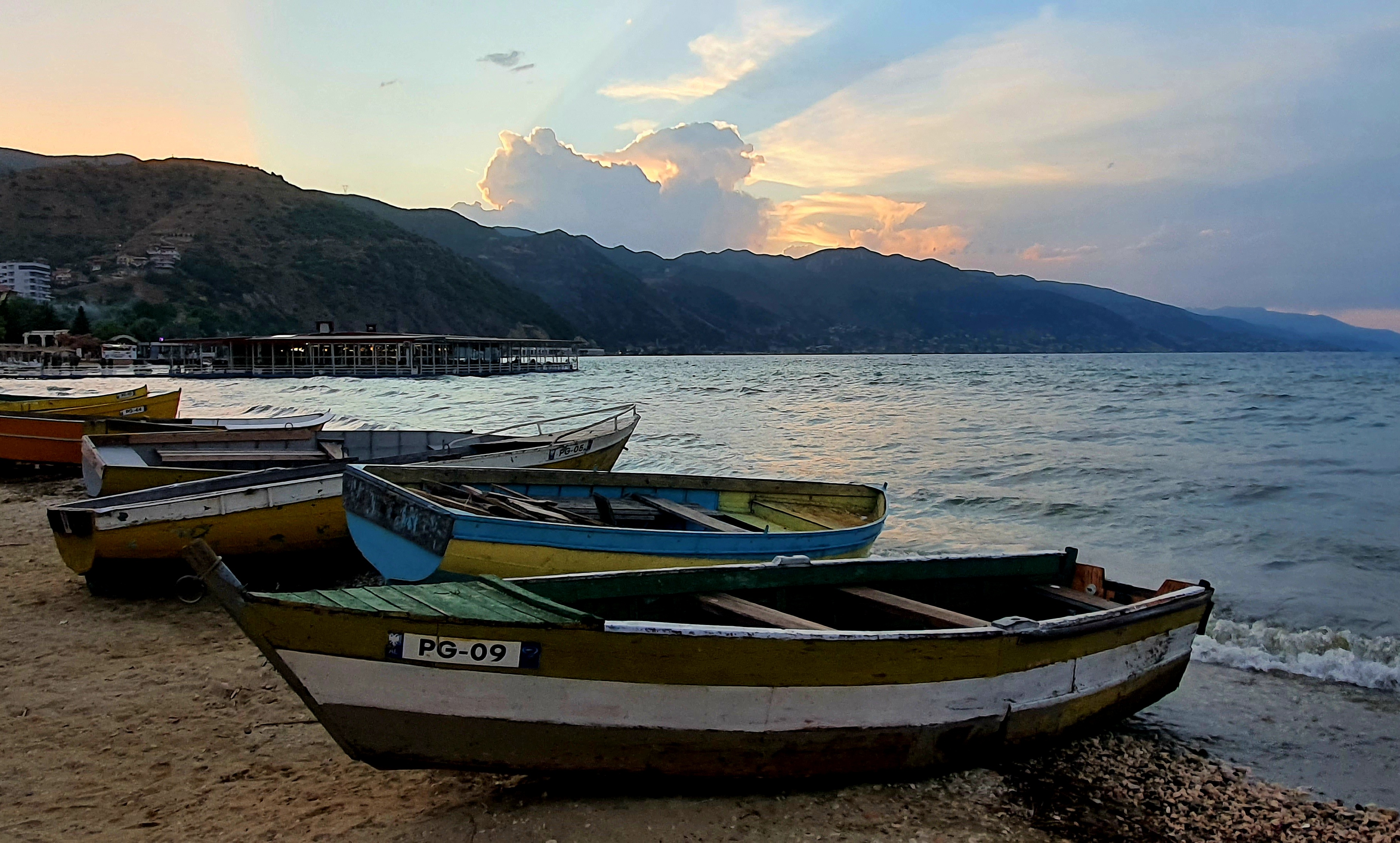


 |
| Some traffic on a bike ride along the entire Albanian shore line of Ohrid lake |

Our next point of interest was 180km down the road, which means a four-hour drive here. Some stretches of road were surprisingly new and smooth, others not so much. And the change from one to the other was often very sudden and unexpected.
For the last hour, the views were excellent, though, lush green mountainsides with ravines running off to all sides. Regrettably, there were no places to stop to take it all in for a minute. And with the roads being curvy and windy all the way, we couldnˋt just halt.
We arrived at Llixhat e Benjes, thermal springs, sweaty and tired, looking forward to a bath.
After seeing the crowds still around at 6pm, the bath was postponed for a couple of hours. By then, all the day-trippers were gone and "only" some 15 camper vans and motorhomes were still around.


In the morning, my human went for a hike down the Lengarica canyon, which the thermal springs come out of.
If I say she was in up to her neck, thatˋs not a figure of speech but to be taken literally. The ground was often covered in ankle-deep mud, threatening to pull ones shoes right off.
After some 15 minutes of passing people, she was all by her lonesome and enjoyed herself immensely.


In theory, we had planned to drive to another canyon from here, the Osum Canyon. After checking on GoogleMaps, I could convince my human that neither of us would have much fun on the drive.
1h41 minutes for 37km, yeah nah!

The 270 km long river arises in the Pindus mountains in Greece and discharges into the Adriatic Sea in Albania.


 |
| One of Mikeˋs playmates, tiny, tiny! |


Comments
Post a Comment